Maps 3D PRO - Hike & Bike app for iPhone and iPad
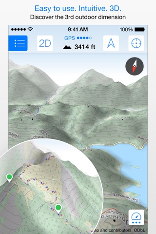
Enjoy exploring the great outdoors? If you’re a fan of biking, hiking and running then Maps 3D is the ideal app designed for planning your outdoor adventures. Whereas other mapping apps are primarily designed for cities and roads, displaying hills and mountains as flat and lifeless features, Maps 3D is packed with amazing features that brings the great outdoors to vibrant life with valleys, hills, mountains and footpaths displaying in full 3D so you’ll know your exact elevation.
*** Featured by Apple with a main banner in the US App Store Navigation category! (02/2013)
*** 3rd place at the 2013 Best App Ever Awards by 148apps.com in Best Outdoors Apps
*** Over 1,700,000 global users!
*** TOP 1 App in Navigation in 75+ countries (as of 01/2017)
*** "The functions are helpful; the compilation of 3D maps is impressive." Macwelt.de – Score: 1.8
*** "An app recommended for hikers, cyclists and horse enthusiasts..." iPhone & iPad apps in Test Magazine, issue 3/2011 – Score: 8/10
STORE ROUTES & USE OFFLINE
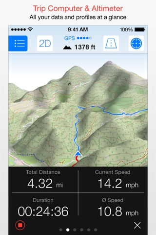
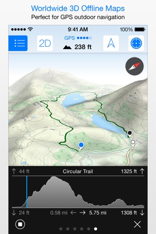
With Maps 3D you’ll have the option to plan, record and share your routes, turning your iPhone into a fully-fledged GPS device so you can log key coordinates and elevations. You’ll also have offline access to worldwide 3D map data which limits the drain on the battery and means that you can pre-load maps to store when you don’t have a signal.
SEARCHABLE MAPS
As an added bonus Maps 3D offers 3D terrain and trip planning, so you’ll never need to worry about getting lost. Towns, streets, mountain peaks and lakes are all searchable, with an accurate and precise map display based on NASA scans of the Earth’s surface combined with the outdoor map OSM (Open Street Map) and the Official USGS topo maps.
LOAD YOUR TRIPS & SHARE
GPX-tracks can be imported via iTunes, email, URL or Dropbox, and recorded tracks can be shared via email, Facebook and Twitter, great for showing your friends your latest outdoor accomplishments.
MORE FEATURES
+++ Load maps in advance over WIFI or 4G before your trek, no internet connection needed thereafter
+++ Record your routes by GPS, all coordinates and exact elevations are logged
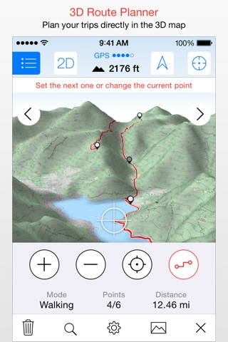
+++ Plan and evaluate routes directly in the 3D map view
+++ Search for towns, streets , mountain peaks, lakes - offline
+++ Distance traveled, current and average speeds all displayed for an ideal trek
GENERAL / NOTES
Background GPS recording can significantly cut battery life
* * * * *
If you like Maps 3D, please remember to leave a positive rating on iTunes!
The movingworld team is working constantly to improve Maps 3D. Any suggestions? Wed love to hear them! Just e-mail them to us at [email protected]. Well try to answer you within 24 hours!
Thank you for using Maps 3D!
Pros and cons of Maps 3D PRO - Hike & Bike app for iPhone and iPad
Maps 3D PRO - Hike & Bike app good for
Quite a nice app for the price. Works quite as announced. No rotation of the app, but it doesnt matter too much.
Fits in real well with my other gps apps. Really like the 3D and elevation! Thanks!
Great app, looks cool and easy to use, could do with Ladscape and full IPad interface.
Just love it
I hunt, I fish, I hike and this is the most valuable app I have. I use it daily, notated what my outdoor adventure.
The only thing I would change is the speed with which a map can be downloaded. I need to get them faster and more reliably so that I can prepare for a trip. Im not going on a trip without it!
Image is pretty cool! I didnt not have time to try for trekking but 3d looks awesome!
Very useful app for me. I bike a lot and the gps really helps for even i dont have sim nor internet connection. You have to make sure you download the map first if you have a wifi so you have permanent map saved in your iphone.
I use and rely on this app for my bike routes and for knowing where are the bike routs to get me to the destination.
But this app doesnt have a route plan or direction if you need instructions to go somewhere
I like this app and didnt replace this app as my bike map.
Some bad moments
Its not quite what I expected. The maps seem to be inaccurate and not consistent with the gps elevation data. E.g. When the cursor is right on 1700 iso height line, and the elevation is stated to be 1550m either information is just wrong. Furthermore the 3D feature is very buggy. According to the 3D maps some rivers are flowing uphill and not in the center of a canyon. Furthermore, simple waypoint connections cause server errors and I cannot save a hike I am planning. A feature to display all planned hikes at once would be nice. I need such an app to plan where to stay and which hikes are close by. I need an overview that is not provided here. Sorry, but google maps is doing a better job!
Deleting thus off my phone. Keeps saying not enough info. If u are on edge of phone service-- like where u usually are when hiking this is useless
It is too slow downloading maps, and also, it does not integrate the maps as one, therefore you have to select a map every time you change area.
Not a bad app; however not great. First, the maps are raster based which means long download times, slow loading and huge file sizes. These days, vector based maps are where its at. The 3D feature sounds neat but in practise, its kind of a gimmick and unless youre in a really mountainous area, the effect is pretty subtle.
The app has track recording as well as routing features; however the latter is pretty useless for a trip of any distance due to the map file sizes ; I guess you could try relying on live map downloads over cellular but at that point why not just use the superior Google maps?
Lastly, support is lacking. Its a paid app and the developers have dropped support for all iOS versions except iOS 7 and have even cited a "new interface". Well based on the screenshots, it looks exacly like the last version. Cmon devs, I know Apple is pushing hard for iOS 7 domination but many devs are at least supporting iOS 6; you can to.
As long as you have an internet connection in the mountains!
The maps download function, for offline use, was taken out. You have to sign to another service (every trail) to do so, but just got errors. I paid for it the to be able to download maps.
Going back to messy motionx.
goodbye 3d maps...
This app is extremely slow on the 6 plus. I would not recommend it at all. Cool features but is barely usable with how much it freezes up. Want me money back. Zero stars if I could.
Usually Maps 3D PRO - Hike & Bike iOS app used & searched for
skitrack,
ski tracker,
skitracks,
ski tracker app,
maps 3d pro,
ski app,
hike tracker,
offline topo maps,
maps 3d gps,
ski tracks,
d-map,
ciclismo,
geocaching gps,
gps navigation & offline maps,
ski tracks lite,
hike & bike,
bikemap gmbh,
and other. So, download free Maps 3D PRO - Hike & Bike .ipa to run this nice iOS application on iPhone and iPad.